Multitask effortlessly on your PC or Mac as you try out Locus GIS Offline Land Survey, a Productivity app by Asamm Software, s. r. o. on BlueStacks.
About the App
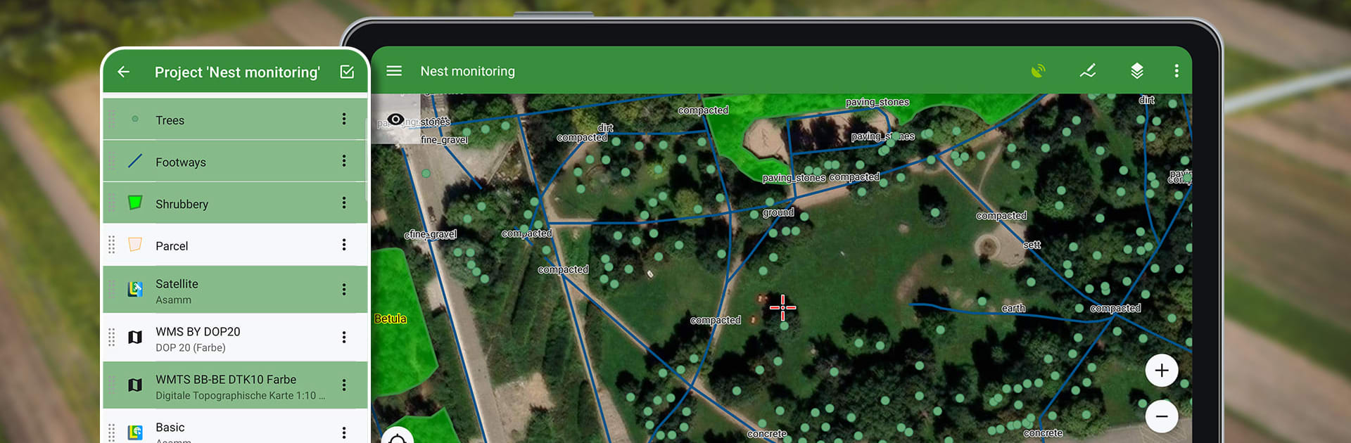
If you’re someone who needs to handle land survey work or field mapping, Locus GIS Offline Land Survey is designed to make life a lot easier—even when you’re far from a decent Wi-Fi connection. Whether you’re in the forest, out in the middle of farmland, or working on an urban project, this app from Asamm Software, s. r. o. gives you full control over collecting, inspecting, and organizing geodata right from your phone or tablet (and sure, it works smoothly on BlueStacks too). Expect a toolbox packed with everything you need to record points, map boundaries, and manage layers—even with precise GNSS support.
App Features
-
Seamless Offline Surveying
No signal? No problem. Collect and update all your field data on the fly, create lines and polygons just by moving around, and attach photos, sketches, or even voice notes to your points. -
Detailed Data Collection
Save locations using your current GPS spot or manual coordinates, set attributes, and use location averaging for extra precision. Add media attachments for richer documentation. -
Import & Export Versatility
Bring in ESRI SHP files, make edits as needed, and send your work back out as SHP or CSV files. You’re free to move entire projects to QGIS, and tapping into your favorite cloud storage (Dropbox, Google Drive, or OneDrive) feels effortless. -
Flexible Mapping Options
Pull up a wide variety of maps—online, offline, or from WMS/WMTS sources. The app supports formats like MBTiles, SQLite, MapsForge, and even lets you add custom OpenStreetMap themes. -
Precise GNSS Integration
Connect to external GNSS units for survey-grade accuracy. The app supports Bluetooth and USB receivers, comes with a robust NTRIP client, and even lets you adjust pole height or antenna details to ensure you’re right on target. -
Measurement & Attribute Tools
Measure distances or areas with simple taps. Search and filter your data, style your layers with smart rules, and add clear text labels for quick reference. -
Organized Data Management
Set up new projects fast with handy templates. Use layers to keep everything tidy, and easily switch between more than 4200 global and local coordinate systems like WGS84 and UTM. -
Customizable Field Forms
Create forms with auto-numbered points, checkboxes, drop-downs, and fields for GNSS attributes, all tailored to the info you need to collect. -
Broad Use Across Industries
Whether you’re mapping trees in forestry, running environmental studies, handling agricultural boundaries, or updating public works maps, the app is built to adapt to your workflow. Even folks working in mining, construction, or energy distribution have tools ready for the job.
Eager to take your app experience to the next level? Start right away by downloading BlueStacks on your PC or Mac.