Why limit yourself to your small screen on the phone? Run Planimeter – GPS area measure, an app by vistech.projects, best experienced on your PC or Mac with BlueStacks, the world’s #1 Android emulator.
About the App
Ever found yourself wanting to quickly figure out the size of a backyard, field, or some mystery patch of land you spotted? Planimeter – GPS area measure, from vistech.projects, is here to help you take the guesswork out of measuring areas and distances right on a map. Whether you’re a casual explorer, into gardening, or need field data for work, this productivity app has a straightforward way to map, mark, and measure just about anything outdoors—all from your device. If you’ve got bigger plans, unlocking the premium toolkit gives you even more ways to customize, save, and share your measurements.
App Features
-
Instant Field Measuring
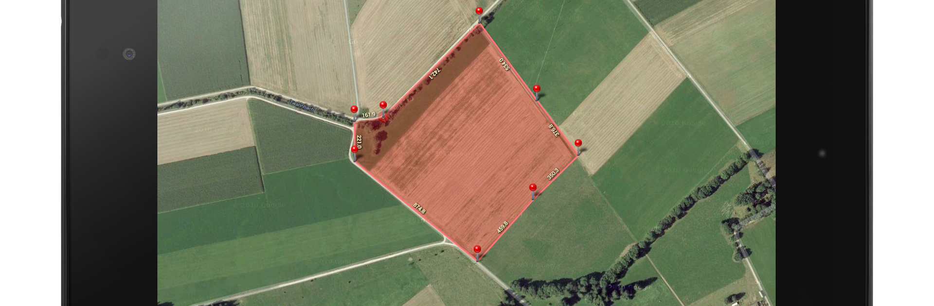
Tap and mark points right on a map to get distances, perimeters, bearing, angles, and GPS coordinates in different formats. Handy for figuring out anything from a new running route to the perimeter of your yard. -
Live GPS Tracking
Want more precision? Use GPS tracking to walk or drive around an area for real-time measurement, with adjustable accuracy and timing settings. -
Smart Pin Placement Tools
Drop pins exactly where you need them thanks to a built-in magnifying tool—no more squinting or dragging and hoping you hit the right spot. -
Advanced Input Options
Manually enter distances and angles if you prefer, making it easy to plot out planned spaces or measure specific paths without walking every inch. -
KML Data & Sharing
Save your maps as KML files, edit them, or share results and screenshots with others. Need to send your findings to colleagues or transfer your routes? Planimeter’s got you covered. -
Multiple Area & Path Handling
Measure several areas or paths, switch between them, and overlay shapes as needed. View polygons or routes directly in external tools like Google Earth for an even clearer picture. -
Smart Editing Tools
Clean up your paths by removing duplicate points, use Notes Mode to label and describe areas, or get directions straight from your saved spots. -
Extra Modes & Calculations
Draw perfect circles (think: setting up perimeter for a garden or a pond), calculate volume or cost estimates by adding heights or area-based rates, and see exact radius around a center point. -
Versatile Use Cases
Perfect for outdoor activities (like biking, hiking, geocaching, or golf), landscape and garden planning, agricultural management, construction layout, forestry, insurance, and even solar panel placement. -
Multiple Language Support
Available in several languages, including English, Portuguese, Russian, German, and Italian.
Planimeter – GPS area measure feels right at home for anyone dealing with land, maps, or just the need for precise measurements. And for those who prefer working on a computer, you can run it smoothly with BlueStacks for that larger screen experience.
Ready to experience Planimeter – GPS area measure on a bigger screen, in all its glory? Download BlueStacks now.