Get freedom from your phone’s obvious limitations. Use SW Maps – GIS & Data Collector, made by Softwel, a Productivity app on your PC or Mac with BlueStacks, and level up your experience.
About the App
Ever found yourself needing to collect location data, draw out maps, or just make sense of rows of coordinates out in the field? SW Maps – GIS & Data Collector by Softwel has you covered. Whether you’re out surveying with high-precision equipment or getting things done with just your phone, this app gives you the tools to collect, manage, and share geographic info without the usual hassles. With an experience that feels flexible and intuitive, it’s built for everyone from professional surveyors to folks who just want to map out a hiking trail or project site.
App Features
-
Custom Mapping, Your Way
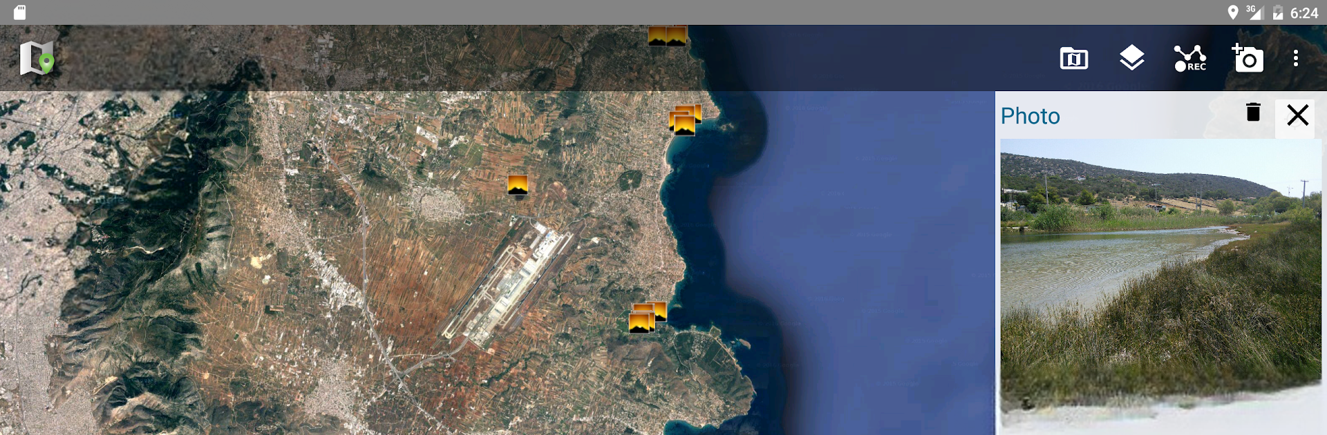
Add points, lines, polygons, and even photos directly onto a variety of base maps. Tag each feature with details—think text notes, numbers, drop-down menus, images, or even audio and video clips. -
High-Precision GPS Support
Got fancy GNSS gear? You can connect external RTK GPS receivers through Bluetooth or USB, boosting your survey accuracy. Even casual users will appreciate the smooth integration with standard GPS when precision’s less critical. -
Import and Export Anything
Bring in shapefiles, KML layers, MBTiles, or GeoJSON formats. Export your work as spreadsheets, CSV files, GeoPackages, or even KMZ (photos included). It’s super handy for sharing survey results, or pulling them up later on bigger screens—BlueStacks makes this effortless on your PC. -
Flexible Layers and Reusable Templates
Create and customize as many layers as you want, each with its own set of attributes. Need to repeat a survey or share your setup? Save everything as a template and reuse or send to a teammate. -
On and Offline Maps
Switch between Google Maps, Open Street Map, or bring in your own overlay from various sources. Cache tiles so you can work even when you lose internet in the field. -
Draw, Measure, and Label
Mark your findings, measure distances or areas, and label features based on your own attribute fields. Need to see everything by category? Attribute-based styling is right there for you. -
Easy Collaboration and Sharing
Share data and entire projects with others. Whether you’re working as part of a team or handing off work to a client, your files are easy to send, and just as easy to open up later. -
Track Projects with GPS
Record GPS tracks to log routes, trips, or even simple walking surveys without fuss. -
Audio and Video Notes
Not just maps and numbers—attach audio notes or even quick videos if you need to remember context or capture what text can’t express. -
Adaptable Storage Options
Load your files straight from your device’s SD card—everything’s organized in folders, so managing maps and survey files stays painless.
Try SW Maps – GIS & Data Collector to streamline your geographic data work, whether you’re coordinating on-site or reviewing results comfortably from your desktop with BlueStacks.
Switch to BlueStacks and make the most of your apps on your PC or Mac.